Today I gave a pretty general talk “Cartography and composition of interactive Maps“ at the WAURISA GIS 2014 conference in Tacoma. The talk is strongly based on Ian Muehlenhaus’s excellent book “Web Cartography. Map design for Interactive and Mobile devices” (2014). This years conference had a strong theme about communication which worked out really well and my presentation fit right in. The presentation slides are here.

Category: Presentations
SpatialKit and SEXTANTE for ArcGIS Desktop
In today’s presentation at King County GIS Center User Group meeting (Seattle, WA, USA) I talked about two powerful free & Open source extensions for ArcGIS. Both of them were released in late 2011: SpatialKit for ArcMap and SEXTANTE for ArcGIS. These extensions offer functionality that is not available at the ArcView level to ArcGIS license owners. This talk will present the extensions and demonstrate many of their tools.
 SpatialKit for ArcMap enables users to use PostGIS data directly in ArcGIS. This means that ArcGIS users can employ the power of the first-class, open source spatial database PostGIS in the same way they use proprietary databases to store, edit and retrieve spatial features via ArcSDE. SpatialKit for ArcMap does not require ArcSDE, ArcInfo, the new Spatial Data Server (SDS) technology, or ArcGIS server.
![]()
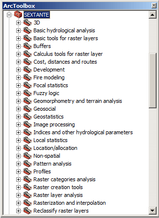
SEXTANTE is a spatial data analysis library written in Java. The SEXTANTE for ArcGIS extension makes it possible to use SEXTANTE (and SAGA GIS) tools directly in ArcGIS, including Model Builder. Together SEXTANTE and SAGA comprise hundreds of spatial analysis functions, including many that are otherwise available in ArcGIS only through proprietary extensions that require additional licenses, such as Spatial Analyst.
 gvSIG CE was presented as a powerful Desktop GIS and at the same time a great alternative to use Sextante integrated with the Grass, and Saga GIS algorithms (Grass algorithms are not available for the ArcGIS extensions at the time of writing). In the near future a version of Sextante will be released that in addition integrates the use of R (Statistical package) algorithms from within Sextante.
downloads
presentation slides (PDF)
zip archive with the 2 extension software packages , documentation and all (45 MB)
external links
Spatial Kit for ArcMap
SEXTANTE
SEXTANTE for ArcGIS
gvSIG CE
Open Source Spatial Database Talk – FOSS4G Barcelona
Karsten Vennemann of TerraGIS will be presenting a 25 minute talk about Open Source Spatial Databases at FOSS4G 2010 in Barcelona (September 6th – 9th 2010).  More than 1200 participants are expected to join this years conference. There will be more than 120 oral presentations during the conference. The abstracts have been posted online including my talk BEYOND POSTGIS – NEW DEVELOPMENTS IN OPEN SOURCE SPATIAL DATABASES. Join me and over 1000 other Open Source GIS friends in Barcelona at this exciting event!
Download my presentation
Web GIS Solutions using Open Source Geospatial Software
The talk held by Karsten Vennemann at the 2008 WAURISA Conference in Seattle gave an overview on building web GIS solutions using open source geospatial software components. A selection of the most advanced and popular open source components, their roles and functionalities in an application framework are described. A complete stack for building web GIS solutions can include a client-server application framework, a web mapping engine supporting cartographic rendering functionality and basic GIS capabilities, data storage solutions such as spatial databases, and additional tools extending or enhancing the basic GIS capabilities of the mapping engine. The concept of an interoperable software solution is illustrated by a variety of examples. Web GIS application frameworks are either complete client-server solutions such as MapFish and Mapbender or Web GIS clients such as Open Layers and Ka-Map. Internet mapping engines such as MapServer and GeoServer render images, provide basic GIS functionality and/or provide the functionality for serving Web mapping services (WMS) and Web feature Services (WFS). Using cached and tiled data in a web GIS application can substantially speed up its response time. TileCache is a server and caching solution that can be used for the creation of cached data from WMS. Feature Server provides data conversion of simple features from a variety of input formats into target formats such as GeoJSON and KML and can be used to integrate the framework with additional applications. Spatial databases include solutions such as PostGIS and MySQL. PostGIS itself provides comprehensive GIS capabilities that can greatly extend the mapping engine’s capabilities and simplify execution of geo-processing tasks using spatial SQL. Additional tools can be integrated with the framework to provide specific GIS capabilities. One example for such a tool is the Perl module GeoCoderUS that can provide geocoding for the entire US based on census Tiger Line files.
Download the presentation slides here.
Terra GIS presents online list matching tool at the WA URISA Conference
[english]
The WA URISA Conference was held April 23-25th, 2007 in
Most commercial GIS desktop software includes tools to spatially join information to a location. A spatial join operation adds information based on the geographical location of one feature to another. This talk illustrates how to build an online tool that can perform spatial joins using open source software. The technical solution presented can support any type of spatial join based on street address and a polygon layer and can be run on both Windows and Linux server platforms. For simplicity we will focus on providing a technical overview on how a web based tool can allow users with little or no GIS knowledge to attach legal district information for
For more information about this tool please contact us. You can download the presentation slides here.
[/english]
[german]Ist der Titel des Vortags den Karsten Vennemann anlaesslich der WA URISA Konferenz in
Download the presentation slides here.[/german]
[french]mais qui.[/french]
[spanish]claro que si.[/spanish]