 |
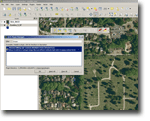
Stream Editing and Custom Attribute Form “Tool” To enable a flexible way to collect data in the field a python plugin for QGIS (a free open source desktop software program) was developed based on an already existing stream digitizing tool.. |
|
| The custom plugin enabled field staff of “Shelterbeltbuilders” (an open land management and restoration company in San Francisco) to quickly adapt custom attribute data collection entry forms and to streamline data entry by using pre-populated drop down fields without complicated configuration work. The plugin supports the creation of custom (user defined) forms for data entry via creating a simple MS Excel spreadsheet, stream digitizing for use on tablet computers in the field (e.g. location and sperad of invasive species), and supports quick attribute data collection (via the custom forms). Using the tool the time needed for field data collection was cut down from a couple of weeks anticipated to several days. Let us know what you might be looking for. | ||
 |
Matching information to member records Do you have data records, such as member or address lists that you would like to complement with additional spatial data? |
|
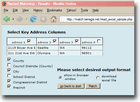
| Would you like to know the geographical distribution of address records in your member or customer database? In all those cases we can help. The example on the left shows a screen shot of a web based tool for automatically matching spatial information such as County, City, School District, Congressional District and Voting District to address files (e.g. member lists containing street addresses can be used). With minimal effort this tool can be customized to match any other spatial information. For more information read  about the tool we built for Washington Conservation Voters Education Fund about the tool we built for Washington Conservation Voters Education Fund an article on online list matching an article on online list matching |
||
Terra GIS
Terrestrial Environment Regional Analysis
Built in (not always) sunny Seattle
Theme: Guten by Kaira